I saw a post on Tech Crunch announcing that Flickr had introduced Geo Tagging (finally!).
I tried it out and I am well impressed, I have to say. It recognises photos which have been previously geotagged and asks if you want to import them. It allows batch tagging (if you have several images which were taken at the one spot) and it uses a simple drag and drop interface.
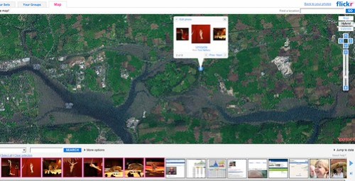
You access the functionality by clickong on the Organize menu (not the dropdown but the Organize menu itself) and then choose the Map tab – not the most intuitive but after that it is entirely straightforward!
Where now is Zooomr‘s usp?
UPDATE: I see the Flickr blog now has a post on this
Now all they need are decent maps of Cork! Why is Microsoft the only one to have detailed maps of the People’s Republic?
Did I hear rumours that Ordnance Survey Ireland will finally be releasing an online map service? Will they licence the data to Google etc I wonder?
Did your images have geodata on them before Flickr offered its service? If so, how did you tell the images their geodetic information?
I’ve used a Garmin GPS to successfully geotag images but that same GPS unit places images more than 20 miles away from where they’re snapped in Ireland when using the Flickr/Yahoo mapping system.
A couple of images did Bernie – I added the geo data using a Firefox bookmarklet which I found via the GeoTagging group in Flickr
For those who are interested in areas not well covered by Yahoo Maps, Panoramio can be an alternative.
In Panoramio you can locate your photos via drag and drop interface using Google Maps. You also can watch the photos in Google Earth through KML feed.
Eduardo